

- Usage in publication:
-
- Bonneville Member*
- Modifications:
-
- Revised
- Reference
- Overview
- Dominant lithology:
-
- Gravel
- Sand
- AAPG geologic province:
-
- Wasatch uplift
Summary:
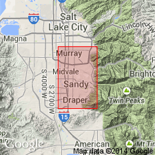
Reduced in stratigraphic rank from Bonneville Formation to Bonneville Member, middle member of Little Cottonwood Formation of Lake Bonneville Group. Comprises lacustrine sediments between altitudes of the Bonneville and Provo shorelines, or at altitudes of about 4,800-4,825 ft and as used here has a more inclusive usage than given by Hunt (1953). Reference locality designated at excavation northeast of Salt Lake City Water Purification Plant, approximately at NE cor SE1/4 sec 2, T3S, R1E, Salt Lake Co area, UT on Wasatch uplift. Measured sections. Correlation chart. Geologic map; mapped with Alpine and Provo Members. Unconformably overlies Alpine Member (rank reduced) of Little Cottonwood Formation. Ranges from several ft to about 100 ft thick. Composed mostly of gravel and sand, and a few patches out silt. Gravel in high shoreline belt is mostly pebble size derived from reworking of underlying Alpine. Gravel in the western belt is interbedded with sand. Sand is medium grained, locally coarse, fine or pebbly, moderately to well sorted, unindurated, massive to well bedded. A silt-clay facies at top is gray to white, calcareous, 1 to 8 ft thick, and occurs as patches. Overlain by Provo Member (new rank) of Little Cottonwood. Of late Pleistocene age.
Source: GNU records (USGS DDS-6; Denver GNULEX).
- Usage in publication:
-
- Bonneville Formation*
- Modifications:
-
- Areal extent
- AAPG geologic province:
-
- Great Basin province
- Snake River basin
Summary:
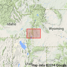
Extended into southeast ID west of Bear Lake into Franklin Co in the Great Basin province and Bannock Co in the Snake River basin. Mapped with Alpine Formation. Pleistocene age.
Source: GNU records (USGS DDS-6; Denver GNULEX).
- Usage in publication:
-
- Bonneville Alloformation
- Modifications:
-
- Revised
- Overview
- AAPG geologic province:
-
- Great Basin province
Summary:
Name changed from Bonneville Formation to Bonneville Alloformation in accordance with classification defined for discontinuity bounded units in the 1983 edition of the North American Stratigraphic Code. Is one of four, and the youngest of the Pleistocene lake cycle deposits differentiated in this report in the Bonneville basin, Box Elder Co, UT in the Great Basin province. Is younger than the newly named Little Valley Alloformation. Unconformably overlies the Promontory Geosol. Composed of most of the surficial deposits below the highest shoreline, and marks the highest altitude attained by Lake Bonneville during the last deep-lake cycle. Includes lacustrine deposits of coarse sand, gravel, silt, clay, tufa, and white marl. Several genera of mollusks analyzed. Subaerial deposits overlie the lacustrine deposits and they consist of fan alluvium, loess, and eolian sand. The Bonneville shoreline is at 1,552 m a s l near outlet at Zenda, ID and at about 1,626 m a s l to west along the Lakeside Mountains, Tooele Co, UT in the Great Basin province. Amino acid analyses.
Source: GNU records (USGS DDS-6; Denver GNULEX).
- Usage in publication:
-
- Bonneville Alloformation
- Modifications:
-
- Revised
- AAPG geologic province:
-
- Great Basin province
Summary:
A newly recognized lacustrine and marginal-lacustrine mud and sand named Cutler Dam Alloformation for exposures along the Bear River in Box Elder Co, UT in the Great Basin province. The lacustrine unit is also a newly recognized Pleistocene lake cycle. The new unit is younger than the Pleistocene Little Valley Alloformation and is separated from the younger Pleistocene Bonneville Alloformation by the Fielding Geosol (new). Cross section.
Source: GNU records (USGS DDS-6; Denver GNULEX).
- Usage in publication:
-
- Bonneville Alloformation*
- Modifications:
-
- Overview
- AAPG geologic province:
-
- Wasatch uplift
Summary:
This report discusses exposures in the Geneva quarry, Point of Mountain area, west end of eastern Traverse Mountains between Salt Lake and Utah valleys, UT on the Wasatch uplift. Consists at this locality of northwest-dipping, well-sorted gravel, sand, and minor silt and sand deposited in a complex of bars and spits during the transgressive phase and maximum stand of the Bonneville lake cycle. Can be identified on basis of its stratigraphic position and radiocarbon ages of 1) 18,600 +/-150 BP on wood found near base, and 2) 20,900 +/-250 BP on wood from a lower altitude in the Salt Lake Sand Co quarry. Bonneville lake cycle culminated in the last glaciation broadly equivalent to oxygen-isotope stage 2. Is separated from the Little Valley Alloformation by the Promontory Geosol. Cross section.
Source: GNU records (USGS DDS-6; Denver GNULEX).
For more information, please contact Nancy Stamm, Geologic Names Committee Secretary.
Asterisk (*) indicates published by U.S. Geological Survey authors.
"No current usage" (†) implies that a name has been abandoned or has fallen into disuse. Former usage and, if known, replacement name given in parentheses ( ).
Slash (/) indicates name conflicts with nomenclatural guidelines (CSN, 1933; ACSN, 1961, 1970; NACSN, 1983, 2005, 2021). May be explained within brackets ([ ]).