

- Usage in publication:
-
- Rock Point member*
- Modifications:
-
- Principal reference
- Dominant lithology:
-
- Sandstone
- Siltstone
- AAPG geologic province:
-
- Black Mesa basin
- Paradox basin
- San Juan basin
Summary:
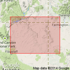
Pg. 3 (fig. 2), 8-10, pls. 1, 2. Rock Point member of Wingate sandstone of Glen Canyon group. Type locality designated. Formerly the "A" division of Chinle formation (Gregory, 1917, USGS Prof. Paper 93). At type locality, consists of sequence of pale reddish brown beds forming ledges of silty sandstone and slopes of siltstone; thickness 344 feet; underlies Lukachukai member; conformably overlies Chinle formation. [Pl. 2, Rock Point member recognized south of Laguna Creek, Arizona. North of Laguna Creek rocks assigned to upper member of Chinle.] Age is Late Triassic.
Type locality: the lower, slope-forming unit exposed in Little Round Rock, a prominent butte, 15 mi south of Rock Point School, [southeastern corner of Little Round Rock 7.5-min quadrangle], Apache Co., Navajo Indian Reservation, northeastern AZ.
Source: Publication; US geologic names lexicon (USGS Bull. 1200, p. 3315-3316).
- Usage in publication:
-
- Rock Point member*
- Modifications:
-
- Areal extent
- AAPG geologic province:
-
- Black Mesa basin
Summary:
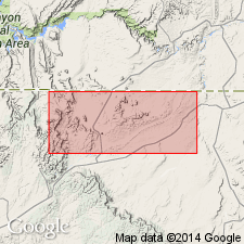
North of Laguna Creek, Apache Co, AZ in the Black Mesa basin, the rocks recognized as equivalent to the Church Rock member of the Chinle Formation of this report and part of Division A of the Chinle of Gregory (1917) are the Upper Triassic Rock Point member of the Wingate sandstone. The arbitrary geographic limit of use of Rock Point and Church Rock is due to disagreement among workers as to whether the rocks should be part of the Chinle or the Wingate; one group believes the rocks intertongue with the underlying Owl Rock member of the Chinle; the second group believes the rocks intertongue with the overlying Wingate. These authors did not find evidence of conglomerate marking base of Wingate or evidence of intertonguing between Church Rock and Wingate.
Source: GNU records (USGS DDS-6; Denver GNULEX).
- Usage in publication:
-
- Rock Point Member*
- Modifications:
-
- Overview
- Areal extent
- AAPG geologic province:
-
- San Juan basin
- Plateau sedimentary province
- Black Mesa basin
Summary:
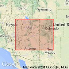
Authors follow use of arbitrary northern limit of this member of the Wingate Sandstone at Laguna Creek. The creek is in Coconino Co, AZ, Plateau sedimentary province, and continues east into Navajo and Apache Cos, AZ, Black Mesa basin. The member is also present in northwest NM, San Juan basin; its western limit is about 20 mi east of Cameron, AZ. Its stratigraphic equivalent north of creek called Church Rock Member of Chinle. Authors believe these rocks assigned to Rock Point have more Chinle than Wingate affinities, and the supposed intertonguing between Wingate and Rock Point occurs in very few places. Is mostly red-brown to brown horizontally bedded siltstone and silty sandstone that overlies Owl Rock Member of Chinle and underlies Lukachukai Member of Wingate. Lower contact placed at top of continuous limestone. Upper contact placed beneath a cross-stratified sandstone. Includes some ledge-forming sandstones of eolian origin. Thins in all directions from Winslow. Is thickest (500+ ft) near Winslow. Cross sections. Stratigraphic chart. Measured sections. Late Triassic age.
Source: GNU records (USGS DDS-6; Denver GNULEX).
- Usage in publication:
-
- Rock Point Member*
- Modifications:
-
- Revised
- AAPG geologic province:
-
- San Juan basin
- Black Mesa basin
Summary:
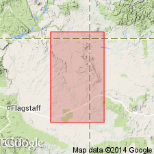
Is removed from Wingate Sandstone of Glen Canyon Group and reassigned to Upper Triassic Chinle Formation. Has a geographic distribution, depositional environment, lithology, bedding, and sedimentary characteristics similar to Chinle, but dissimilar from cliff-forming sandstone of the eolian erg of the restricted Wingate of this report. In earlier reports, red beds above Owl Rock Member of Chinle were assigned arbitrarily to Rock Point south of Laguna Creek around Defiance uplift and to Church Rock Member of Chinle north of Laguna Creek. No one has disputed the correlation of these members with each other and with Dolores Formation. Consists of red-brown, very fine grained sandstone and silty sandstone virtually identical to Church Rock. Both contacts sharp. Sandstone of Wingate fills desiccation cracks that extend about 15 cm into siltstone at top of Rock Point--a special characteristic of the Wingate-Chinle contact. Weathers to thin- to thick-bedded ledges interbedded with slope-forming unit. Has horizontal laminations, 0.5 cm diameter trace fossils, and bioturbated texture. Considered an interbedded fluvial lacustrine, eolian sand sheet and dune deposit laid down in a subsiding continental basin in northwest NM (San Juan basin) and adjoining northeast AZ (Black Mesa basin). Cross sections.
Source: GNU records (USGS DDS-6; Denver GNULEX).
For more information, please contact Nancy Stamm, Geologic Names Committee Secretary.
Asterisk (*) indicates published by U.S. Geological Survey authors.
"No current usage" (†) implies that a name has been abandoned or has fallen into disuse. Former usage and, if known, replacement name given in parentheses ( ).
Slash (/) indicates name conflicts with nomenclatural guidelines (CSN, 1933; ACSN, 1961, 1970; NACSN, 1983, 2005, 2021). May be explained within brackets ([ ]).